Building the West by the Beautiful Forks.
Belle Fourche...French for "Beautiful Forks"
And the locals pronounce it…”Bel Foosh”.
Our Namesake
The Belle Fourche River
Belle Fourche River (French for “beautiful fork”) was named by French fur traders, referring to the confluence of what is now known as the Belle Fourche and Redwater Rivers and the Hay Creek.
The river was named in the 1780’s, many years before the town was established.
The new settlement was located at the forks of Hay creek, Redwater River and Belle Fourche River.
Our Pioneering Story
A Deal with the Railroad
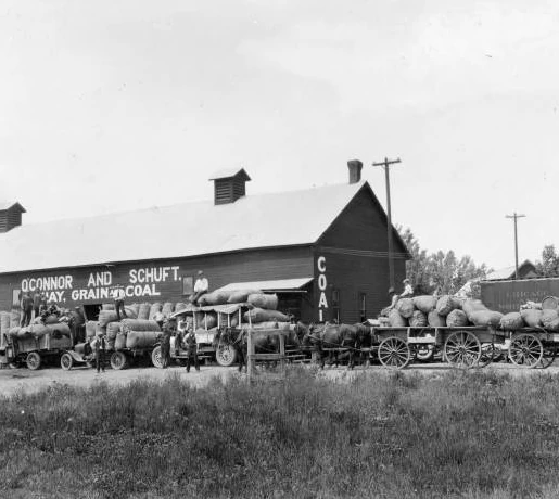
In 1876 gold was discovered in the northern Black Hills. As the gold mining made Deadwood famous, the area north of the Black Hills was settled by pioneers who would become the source of the necessary supplies.; meat, milk, and vegetables.
In 1890 the Fremont, Elkhorn and Missouri Valley railroad reached the area and began looking toward the plains to the west. Seth Bullock, frontier marshal and rancher on the Redwater, quietly worked at persuading officials to build a depot on the site of De Mores, an early day stage station.
On December 28, 1890, the railroad reached the area and was joined by the depot and the new town of Belle Fourche was established.
Seth Bullock and his partner Sol Star donated a right-of-way against his ranch to the Fremont, Elkhorn and Missouri Valley railroad and donated land for their Pioneer Townsite company for a land auction held on June 9th, 1891.
Belle Fourche was soon platted, and lots were sold. Free lots were offered to businesses moving in from Minnesela and despite the hatred generated by the struggle, many merchants accepted.
Livestock Shipping
A Hub for All Things Livestock
Belle Fourche is one of the most important livestock shipping railheads in the West. The railroad shipping corrals were on the Middle Creek, north of the Belle Fourche River which made the cattle separated from the townsite which was safer for both animals and people.
The sheep industry became active in the 1890’s and remains even today. The wool shipping warehouse “Center of the Nation” is one of the largest in the US, handling nearly 2,000,000 pounds.
The city is the trading center for a three-state agricultural area encompassing 21,000 square miles in NW South Dakota, NE Wyoming, and SE Montana.
A hub for livestock auctions and wool shipping, Belle Fourche also is the center of a bentonite mining industry.
The downtown area’s architecture retains the aura of the early 1900’s and is listed as an Historic Commercial District on the National Register of Historic Places.
Geographic Center of the Nation
About the Monument
On August 21, 2007, the Belle Fourche Chamber of Commerce and the Center of the Nation Planning Committee unveiled a new monument to designate and celebrate Belle Fourche, South Dakota as the Geographic Center of the United States.
The 21-foot diameter structure is made of etched South Dakota granite with a 12-inch bronze marker from the National Geodetic Survey. The Monument is located at the Tri-State Museum and Visitor Center.
How did Belle Fourche receive the honor of being the Geographical Center of the Nation?
According to the National Geodetic Survey, determining the geographic center of an irregular area on the earth’s surface is a precarious business at best. There is no unique solution and none of any scientific significance.” Several methods of approach are available. The one employed by the National Geodetic Survey is probably best termed as the center-of-gravity method.
Imagine a map of the area of which the geographic center is to be determined, has been placed on a piece of cardboard of uniform thickness and that this is cut carefully along the outline of the map. The center of gravity of this map outline, or what might be called the geographic center, is that point at which the map will balance.
If Belle Fourche is the Geographic Center of the Nation what is in Lebanon, KS?
Lebanon, KS is the center of the 48 conterminous states. Rugby, ND is the center of North America.
How do you get to the actual geographic center of the nation?
To drive to the actual geographic center of the nation, one needs to drive 13 miles on HWY 85 north from the intersection of HWY 85 and 212. Turn left onto Old HWY 85 (look for a small blue sign with white lettering) and drive 7.8 miles until you see a barn on your left hand side. One the right hand side of the road you will see a small sign in red white and blue telling you that you have reached the Center of the Nation. Looking into the pasture, you will see a US Flag flying freely. Feel free to park and climb through the barb wire fence and make the short walk out to the location…make sure to watch for cow pies and snakes! At the location you will see the survey marker highlighting the “Center of the Nation”.
Why is the new “Center of the Nation” Monument located at the visitor’s center?
The actual geographic center of the nation is located on private property. While the rancher does allow people to experience the site, he does not want to develop the area. The National Geodetic Survey has designated Belle Fourche as the town closest to the actual site allowing Belle Fourche to have the monument in the town.
Greetings from Belle Fourche | Dakota Life
Belle Fourche Walking History – Episode 1
Belle Fourche Walking History – Episode 2


